This poster map depicts the diversity of soil types across Africa.
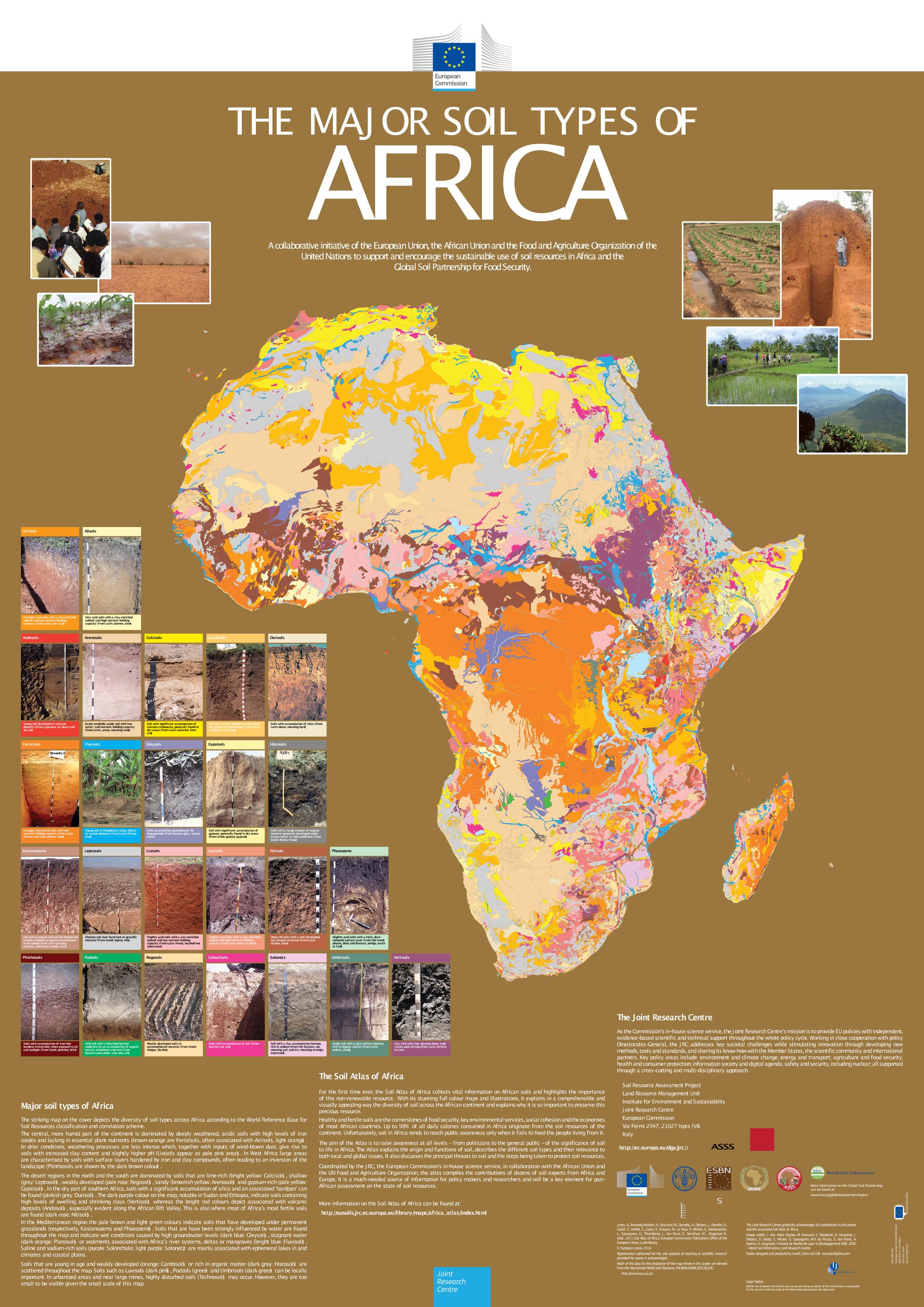
The central, more humid part of the continent is dominated by deeply weathered, acidic soils with high levels of iron oxides and lacking in essential plant nutrients (brown-orange are Ferralsols, often associated with Acrisols, light orange). In drier conditions, weathering processes are less intense which, together with inputs of wind-blown dust, give rise to soils with increased clay content and slightly higher pH (Lixisols appear as pale pink areas). In West Africa large areas are characterised by soils with surface layers hardened by iron and clay compounds, often leading to an inversion of the landscape (Plinthosols are shown by the dark brown colour).
The desert regions in the north and the south are dominated by soils that are lime-rich (bright yellow: Calcisols), shallow (grey: Leptosols), weakly developed (pale rose: Regosols), sandy (brownish yellow: Arenosols) and gypsum-rich (pale yellow: Gypsisols). In the dry part of southern Africa, soils with a significant accumulation of silica and an associated ‘hardpan’ can be found (pinkish grey: Durisols). The dark purple colour on the map, notable in Sudan and Ethiopia, indicate soils containing high levels of swelling and shrinking clays (Vertisols) whereas the bright red colours depict associated with volcanic deposits (Andosols), especially evident along the African Rift Valley. This is also where most of Africa’s most fertile soils
are found (dark rose: Nitisols).
In the Mediterranean region the pale brown and light green colours indicate soils that have developed under permanent grasslands (respectively, Kastanozems and Phaeozems). Soils that are have been strongly influenced by water are found throughout the map and indicate wet conditions caused by high groundwater levels (dark blue: Gleysols), stagnant water (dark orange: Planosols) or sediments associated with Africa’s river systems, deltas or mangroves (bright blue: Fluvisols). Saline and sodium-rich soils (purple: Solonchaks; light purple: Solonetz) are mainly associated with ephemeral lakes in arid climates and coastal plains.
Soils that are young in age and weakly developed (orange: Cambisols) or rich in organic matter (dark grey: Histosols) are scattered throughout the map. Soils such as Luvisols (dark pink), Podzols (green) and Umbrisols (dark green) can be locally important. In urbanized areas and near large mines, highly disturbed soils (Technosols) may occur. However, they are too small to be visible given the small scale of this map.
JONES Arwyn;
BREUNING-MADSEN Henrik;
BROSSARD Michel;
DAMPHA Almami;
DEWITTE Olivier;
HALLETT Stephen H.;
JONES Robert J A;
KILASARA Method;
LE ROUX Pieter;
MICHELI Erika;
MONTANARELLA Luca;
SPAARGAREN Otto;
TAHAR Gallali;
THIOMBIANO Lamourdia;
VAN RANST Eric;
YEMEFACK Martin;
ZOUGMORE Robert;
2018-01-18
Publications Office of the European Union
JRC91922
978-92-79-42408-3,
1831-9424 (online),
EUR 26857,
OP LB-NA-26857-EN-N (online),
http://eusoils.jrc.ec.europa.eu/library/maps/africa_atlas/index.html,
https://publications.jrc.ec.europa.eu/repository/handle/JRC91922,
10.2788/17215 (online),
